As winter loosens its grip, Les Contamines-Montjoie emerges from its chilly slumber, offering a fresh perspective for outdoor enthusiasts. In this post, we’ll guide you through a curated selection of trails that capture the essence of the season.
From leisurely strolls along flower-lined paths to more challenging routes revealing panoramic mountain vistas, these hikes showcase the natural beauty that blossoms around this idyllic alpine location during the spring months. Plus, the region is home to some great gentle hikes which are ideal for families of novice hikers. So lace up your hiking boots and join us as we navigate through the rejuvenating landscapes of Les Contamines-Montjoie!
Book your stay in the Alps this spring
The top spring hikes around Les Contamines-Montjoie
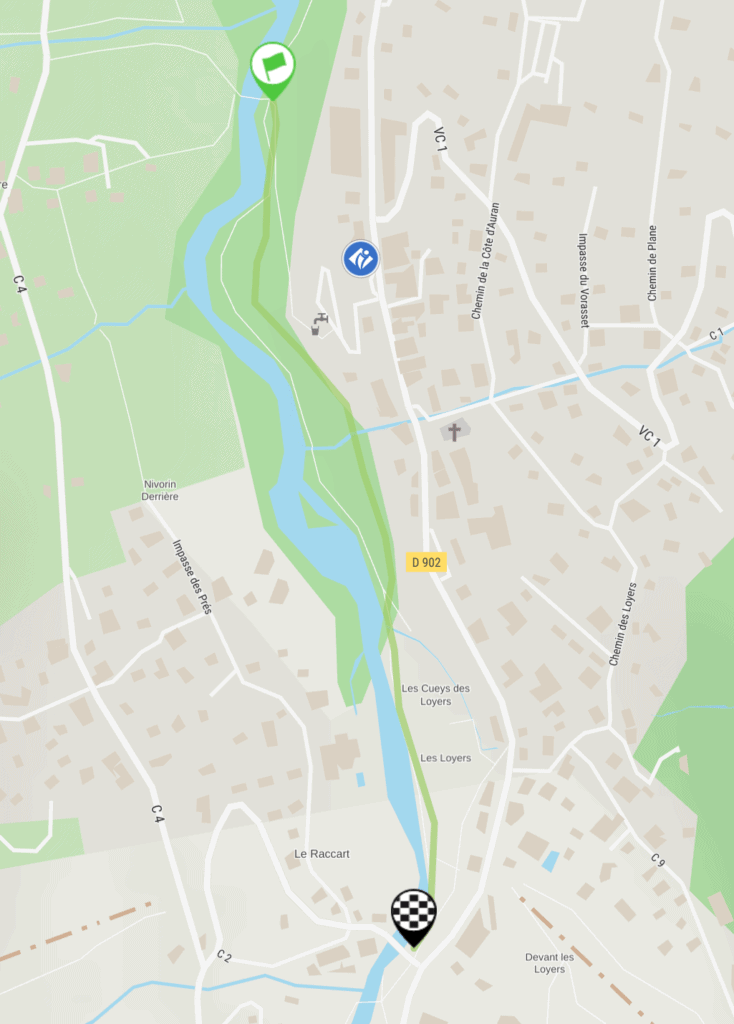
1. The Banks of the Bonnant
Distance: 2.6km
Duration: 1h
Elevation gain: 35m
The Pont des Loyers hike is an easy trail with a duration of 1 hour for the round trip. You’ll start from the parking area above the Pont des Loyers and cover a distance of 2.6km.
The journey begins by crossing the road from the car park towards the Pont des Loyers. Take the GR5 trail, a wide path descending along the left bank of the torrent. The slope diminishes quickly, and a pump track and children’s games become visible on the right.
The path then levels out, entering a sparse undergrowth. Along the way, you can take a break in the shade of the trees by the water. This makes it an ideal spot for relaxation, especially on warmer spring days. The trail ends at the bridge leading to the small hamlet of Chovettaz – the return journey follows the same route.
The hike also offers insights into the geography of the region, specifically the Bon Nant. Originating from the Nature Reserve at the Col du Bonhomme, the Bon Nant flows approximately 15km into Le Fayet, serving as a crucial tributary of the Arve.
There are accessible toilets in the car park below the Contamines tourist office or at the ice rink. The hike is recommended during the clear period from April 1st to November 30th.
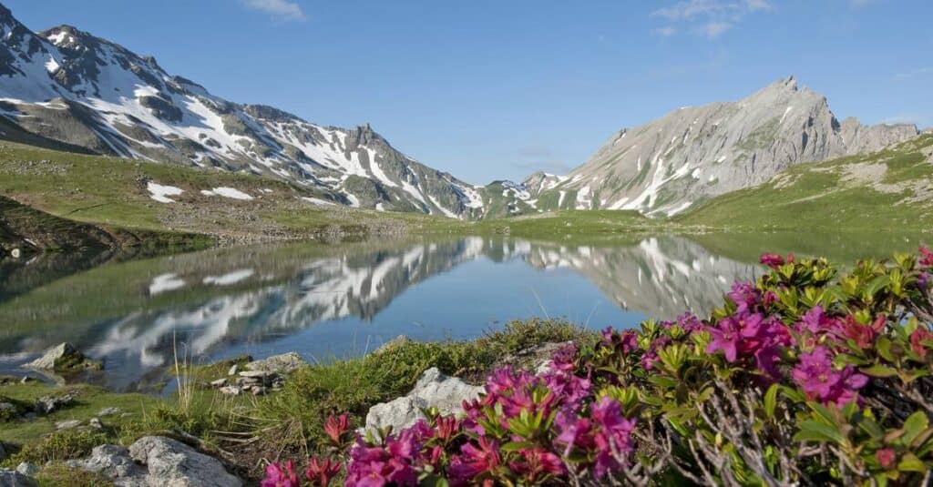
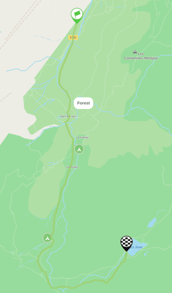
2. The Jovet Lakes
Distance: 14.3km
Duration: 6h 40m
Elevation gain: 964m
This hike unfolds in Notre-Dame de la Gorge, with the Roman road, the natural bridge, and the Roman Bridge. The trail continues through Nant-Borrant, La Balme, and the Jovet lakes.
Just five minutes from the first lake, the second lake is smaller and inhabited by marmots and ibexes.
Rated as difficult, the hike demands 3 hours and 45 minutes for the ascent. The descent lasts 2 hours and 55 minutes, resulting in a total duration of 6 hours and 40 minutes. The elevation gain reaches an impressive 964 metres, making it a challenging but rewarding adventure.
The itinerary starts at the Parking de la Gorge, accessible by crossing the centre of the village and heading towards Notre-Dame de la Gorge. En route, hikers can find refuge in Nant-Borrant, La Balme, and Les Prés, located approximately 30 minutes from the trail.
Follow the numbers indicated on the crossroads signs: n° 32, 33, 34, 35, 109, 36, 23, 24, 29, and 118. The return journey follows the same path.
Hikers can enjoy this trail free from snow from around mid-May. However, consider wearing snowshoes if the path is not clear.
Book your stay in the Evasion Mt Blanc
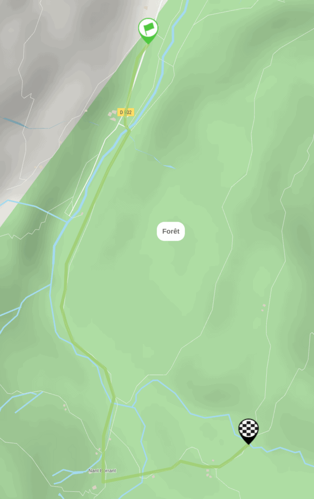
3. La Cascade de Combe Noire
Distance: 5.2km
Duration: 2h 30m
Elevation gain: 200m
Nestled within the Nature Reserve, the spectacular Combe Noire is situated in the heart of the Laya forest. Offering a fairly easy hiking route, it’s an ideal choice for families seeking a blend of natural beauty and accessibility. The route is best enjoyed from May onwards.
With a moderate difficulty level, the journey takes approximately 1 hour and 50 minutes, ideal for all skill levels. The elevation difference of 200m adds a touch of challenge, creating a satisfying experience for hikers.
The route starts from the Notre-Dame de la Gorge car park, easily accessible by crossing the village centre and following the direction towards Notre-Dame de la Gorge.
Embarking from the baroque chapel of Notre-Dame de la Gorge, the journey follows the Roman Road towards Nant Borrant. Upon reaching the refuge bearing the same name, the path takes a left turn towards Combe Noire.
Traversing the Bonnant, amidst the Laya forest, hikers are led to the Laya mountain pasture. The final stretch involves a leisurely flat traverse, leading to the Combe Noire waterfall.
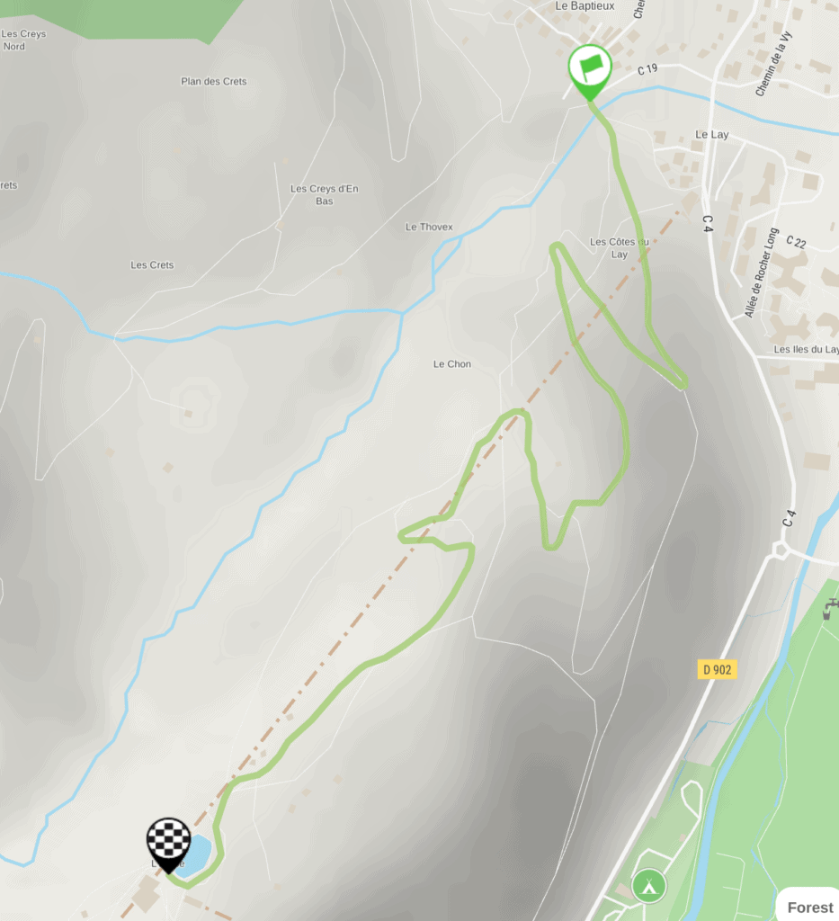
5. Lake Etape from Baptieu
Distance: 2.5km
Duration: 2h 30m
Elevation gain: 367m
Embark on an enjoyable 2.5km family-friendly excursion lasting approximately 2 hours and 30 minutes. This easy walk leads to the serene Lac de l’Etape, offering picturesque vistas of Les Contamines and Mont Blanc.
Designed for ease and accessibility, it’s ideal for families, ensuring a pleasant experience for both adults and children alike. The departure point is the Baptieu car park, setting the stage for a leisurely exploration.
The highest altitude attained during the hike is 1,478m, featuring a manageable elevation gain of 367m. This also means the path is fairly clear of snow from April onwards.
Begin from the sign at the bottom of Chemin du Chon, and follow the 4×4 path leading towards “L’Etape.” Then, at the first hairpin intersection, take a right onto the 4×4 path. Continue until you encounter a second hairpin on the left.
Near the cable car pylon situated alongside the path, make a left turn at the intersection onto the “chemin d’été,” still heading towards “L’Etape.” Traverse through the forest and mountain pastures before reaching the idyllic destination of Lac de l’Etape.
For the return journey, follow the same route taken earlier. Alternatively, take the forest route via the Chon Oratory, although this option features a steeper trail.
This well-rounded and easily navigable hike promises not only beautiful landscapes but also flexibility of routes.
Visit the Evasion Mt Blanc
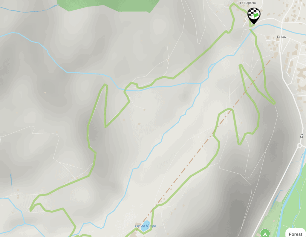
6. Loop Le Baptieu, Colombaz, L’Etape
Distance: 5.5km
Duration: 2h 20m
Elevation gain: 300m
Discover the serene beauty of the green mountain pastures and quaint high-altitude chalets of Colombaz on this hiking loop. Offering a magnificent viewpoint of the Mont-Blanc massif, the summit emerges between the Dômes de Miage and the Aiguille de Bionnassay, creating a breathtaking backdrop for the walk.
Rated with a comfortable blue difficulty level, the ascent takes approximately 1 hour, with a total duration of 2 hours and 20 minutes. The elevation gain is a manageable 300m, and the route follows a scenic loop. The journey commences at the Baptieu car park, easily accessible by passing through the village centre, following the ski area direction, and parking at Baptieu, just before the hamlet of Lay. Along the route, hikers can find the “Colombaz” inn and the “L’Etape” restaurant, providing a handy stop-off.
Starting from the bottom of the Baptieu hamlet, the walk leads through Colombaz on a dirt road, passing by the inn of the same name. From the inn’s terrace, enjoy stunning views of the Dômes de Miage and the Aiguille de Bionnassay. Continuing for 200m, the path presents a charming journey through the heart of nature.
At a fork in the trail, a left turn guides hikers towards l’Etape. Crossing the Nant Rouge, the trail ascends into the forest, leading to l’Etape, its serene lake, and the accompanying restaurant.
The descent takes a left turn towards Les Contamines along the track, skillfully avoiding the road. Navigation is guided by following the numbers indicated on signs at intersections, including 121, 9, 10, 101, 100, 99, 98, 96, and 97.
At the end of the journey, hikers are invited to relish the panoramic view from the terrace of the Auberge de Colombaz, where you can enjoy a drink or some local specialties. The Auberge de Colombaz is open year-round, offering a welcoming space to unwind amidst the stunning surroundings.
7. The Val-Montjoie Trail
Distance: 16km
Duration: 6h
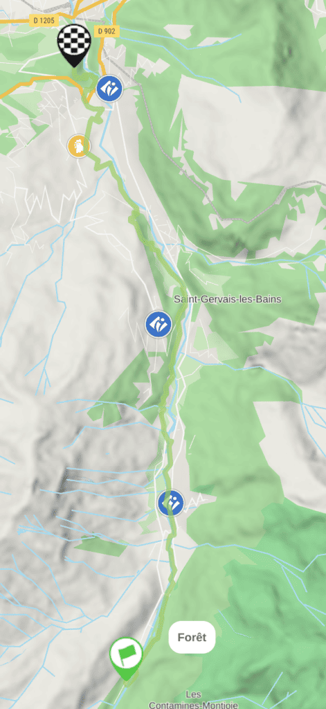
Head out on a challenging yet rewarding 16km round-trip hike with a red difficulty rating. Start from either the Thermes de Saint-Gervais-Le-Fayet car park or the La Gorge aux Contamines car park. To access the trail from Le Fayet, head towards the thermal baths and park in the designated lot. Alternatively, those starting from the village of Les Contamines can head towards Notre-Dame de La Gorge, descend towards the valley bottom, and park at the Gorge car park.
This route traverses the captivating Bonnant gorges, following the course of the torrent to Les Contamines, weaving through meadows and villages. The journey unfolds with breathtaking views of the Aiguille de Bionnassay and the Dômes de Miage, showcasing the natural splendor of the surroundings. A must-visit site along the way is Notre-Dame de la Gorge, featuring a Roman road and a baroque chapel. For the return journey, buses are available.
To commence the hike from the thermal baths, cross the bridge on the right and follow the path along the gorge. Ascend to the top, cross the historic Pont du Diable, and reach the church and the Saint-Gervais ice rink. As the trail progresses, head towards the Pratz plain and descend to the Croëts footbridge. This route is also feasible in the opposite direction, starting from Notre-Dame de la Gorge, passing through Les Contamines Montjoie, Saint-Gervais, and concluding at Le Fayet. The flexibility of return buses ensures a convenient and customisable hiking experience.